


| Width | 43,200 pixels | |
| Height | 21,600 pixels | |
| 300 dpi print width | 144.0 inches | 365.8 centimetres |
| 300 dpi print height | 72.0 inches | 182.9 centimetres |
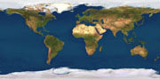
The Planetary Visions Satellite Imagemap combines data from three satellite systems and four digital maps to give the most complete and realistic cloud-free texture map of the Earth's entire land and sea surface. Areas of forest, mountain, desert, ocean and ice cover are easily recognised in their natural colours.
The Satellite Imagemap is available for licensed use in film and television graphics, print and multimedia titles, museums, exhibitions, advertising and merchandising, with global, continental or user-defined coverage. It is being continually improved as new data becomes available.
The Satellite Imagemap is available for licensed use in film and television graphics, print and multimedia titles, museums, exhibitions, advertising and merchandising, with global, continental or user-defined coverage. It is being continually improved as new data becomes available.