


| Width | 3,600 pixels | |
| Height | 3,600 pixels | |
| 300 dpi print width | 12.0 inches | 30.5 centimetres |
| 300 dpi print height | 12.0 inches | 30.5 centimetres |
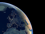
This simulated view shows the Earth at night based on a combination of day-time and night-time satellite imagery. A cloud-free mosaic of thousands of images taken by NOAA Polar Orbiter weather satellites was combined with images taken at night by the US Air Force Defense Meterological Satellite Program (DMSP). This system is sensitive enough to take pictures of clouds by moonlight, and shows light sources such as cities, industrial areas, oil fields and shipping.