



| Width | 3,600 pixels | |
| Height | 3,600 pixels | |
| 300 dpi print width | 12.0 inches | 30.5 centimetres |
| 300 dpi print height | 12.0 inches | 30.5 centimetres |
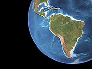
This simulated view of the Earth combines a natural-colour land surface with a colour-coded ocean depth map. A cloud-free mosaic of thousands of images taken by NOAA Polar Orbiter weather satellites was combined with ocean depth data to reveal sea floor features such as the continental shelves, seamounts, trenches and mid-ocean ridges. Major lakes and river systems are also highlighted using data from a hydrological map.