Earth ocean depth texture map (4127)
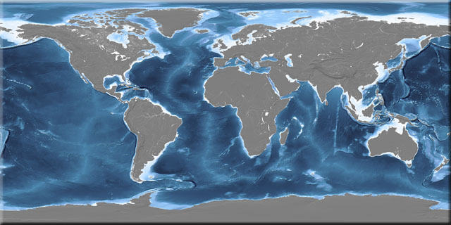
This texture map shows ocean depth in continuous-tone colour and hill-shaded, with monochrome hill-shading on the land. The emphasis is on the ridges, shelves, seamounts and trenches of the ocean floor, although lakes and major rivers are also portrayed. This map was prepared from a unique combination of traditional hydrographic survey data and the latest satellite-derived bathymetry.
Data Sources
Terrain: improved SRTM3 with GTOPO30 north of 60°N and south of 60°S
Bathymetry: ETOPO2 World Relief and GEBCO Gridded Bathymetry
Coastline and lakes: Digital Chart of the World (DCW)
Rivers: HYDRO1K hydrology, corrected to DCW rivers
| Resolution | Columns | Rows | File size | 300 dpi print width |
|---|
| 32.0 km | 1,350 | 675 | 3 MB | 4.5 in | 11.43 cm |
| 16.0 km | 2,700 | 1,350 | 10 MB | 9.0 in | 22.86 cm |
| 8.0 km | 5,400 | 2,700 | 42 MB | 18.0 in | 45.72 cm |
| 4.0 km | 10,800 | 5,400 | 167 MB | 36.0 in | 91.44 cm |
| 2.0 km | 21,600 | 10,800 | 667 MB | 72.0 in | 182.88 cm |
Samples
