Coloured by height Earth texture map (4120)
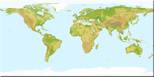
Our worldwide Land Topography texture map is coloured-by-height and hill-shaded in a traditional topographic colour scheme. With a pixel size of 1km, large sand dunes can be seen in the Sahara, Arabian and Gobi Deserts. Optional overlay layers show rivers, lakes and areas of permanent snow and ice cover. Our unique rivers layer shows rivers tapering in strength along their length based on hydrological analysis of their drainage area.
Data Sources
Terrain: improved SRTM3 with GTOPO30 north of 60°N and south of 60°S
Coastline and lakes: Digital Chart of the World (DCW)
Rivers: HYDRO1K hydrology, corrected to DCW rivers
Icecaps: satellite-derived land cover map
Texture maps at a pixel size of 100 metres can be produced to order for any location between 60 degrees North and South, based on the most detailed publicly-available digital terrain data (SRTM3). Click here for more information about our improvements to this spaceborne radar-derived source data.
| Resolution | Columns | Rows | File size | 300 dpi print width |
|---|
| 32.0 km | 1,350 | 675 | 3 MB | 4.5 in | 11.43 cm |
| 16.0 km | 2,700 | 1,350 | 10 MB | 9.0 in | 22.86 cm |
| 8.0 km | 5,400 | 2,700 | 42 MB | 18.0 in | 45.72 cm |
| 4.0 km | 10,800 | 5,400 | 167 MB | 36.0 in | 91.44 cm |
| 2.0 km | 21,600 | 10,800 | 667 MB | 72.0 in | 182.88 cm |
| 1.0 km | 43,200 | 21,600 | 2,670 MB | 144.0 in | 365.76 cm |
Samples
